


LandQuest® Realty Corporation is a unique real estate company specializing in marketing ranches, farms, oceanfront, private islands, marinas, lodges, resorts, lakefront, riverfront, recreational, development, investment, unique, trophy, timbered, fishing and hunting properties throughout British Columbia.

A true jewel of the Cariboo. This unique ranch property sits perched 200 feet above the mighty Fraser River and offers a unique topographical setup found nowhere else in the province. Set amongst the lush hay fields, pasture and farm infrastructure is a stunning country home offering 4,100 ft2 of living space. This is a once in a lifetime opportunity.
Personal Real Estate Corporation
chase@landquest.com 778-927-6634
Court ordered sale. Prime 159-acre agricultural farm on Vancouver Island, with a history of diverse farming operations. Two residences, extensive barns/outbuildings, and abundant water supply. Ready for immediate production, offering a rare opportunity in a sought-after location.
Foreign Buyer Ban does not apply to this property

Scenic agriculture land a couple kilometres from Mabel Lake. 446 acres over 2 titles with 1.5 km on the Shuswap River, 100 acres of hay + an additional 20 acres cleared & ready to be seeded. 10,000 ft2 steel hay shed. 120± acres outside the ALR. Zoned for 18 acre lots.

8.55 acres along Discovery Passage in the “Salmon Capital of the World”, this serene oceanfront property with an off-grid cabin, 400 ft of water frontage & views of Quadra Island. Roughed-in driveway & an easement for beach entry, all connected to civilization via FSR to HWY 19.
Foreign Buyer Ban does not apply to this property

Opportunity to purchase 3.5 acres of Commercial zoned property on Highway 20 'downtown' Nimpo Lake. Property offers highway frontage water and power. It is partially treed and in a prime location with scenic lake views.
Foreign Buyer Ban does not apply to this property

Oceanfront property with custom 3 bedroom, 2 bathroom home, separate studio/guest cabin. Private marina, moorage at your doorstep. Road accessible with services. Ideally situated in the Southern Gulf Islands with easy access to Vancouver Island.

Fully serviced 135 site RV park on Moyie River with 35 Riverfront sites & 105 inland sites. 101.59 acres (2 titles). 3 bdrm residential house, 5,000 ft2 storage building. No zoning and lots of land for motel, truck stop etc, or there is potential for park expansion (sewer & water for 300+ sites).
Foreign Buyer Ban does not apply to this property
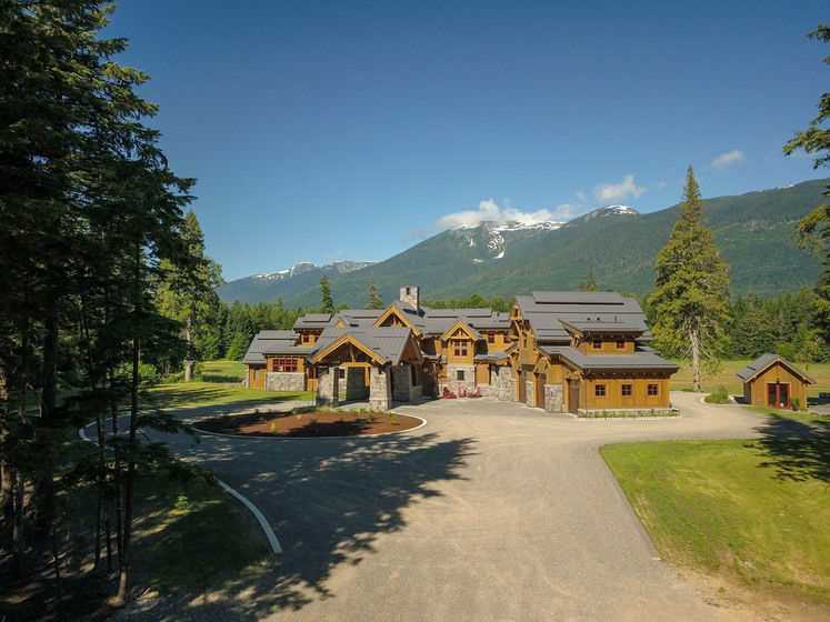
World class ultra luxurious 6,475 ft2, 6-bdrm timber-frame lodge on a 305-acre ranch skirting the banks of the mighty Skeena River is a masterpiece in detail, design & décor. Ranch operators live in a separate caretaker log house on the grounds, so owners can enjoy the unprecedented tranquility.

World class salmon & bottom fishing at your doorstep. This floating lodge is located on Union Island in Kyuquot Sound on the coast of Vancouver Island. 4 guest rooms, a 3-bedroom cabin, dining room, outdoor kitchen area & a fish processing facility catering to guests & other lodges.
Foreign Buyer Ban does not apply to this property

Waterfront, privacy, serenity, hunting and fishing, and the extensive BC wilderness are all at your fingertips. This exclusive offer features multiple dwellings housing up to 32 people, giving plenty of options to retreat from the whirlwind of life.
Foreign Buyer Ban does not apply to this property

Off-grid acreage in the tight knit community of Beaton, one of BC’s best kept secrets! Land is zoned Resort Commercial & allows uses such as a single-family home + a secondary dwelling unit, campground, cabins, lodge etc. Drilled well in place. Lake access nearby.
Foreign Buyer Ban does not apply to this property
Scenic off-grid acreage mostly covered with an amazingly lush mature forest. A driveway leads up to a flat open clearing. Zoned Resort Commercial & allows uses such as a single-family home + a secondary dwelling unit, campground, cabins, lodge etc. Drilled well in place. Lake access nearby.
Foreign Buyer Ban does not apply to this property

127.25-acre lot in a prime location adjacent to a quiet, well-established subdivision. Minutes from schools, shopping and all amenities. This property combines urban convenience with rural tranquility and stunning views offering the perfect opportunity to build your dream home.
Personal Real Estate Corporation

Court Ordered sale. 4,150± ft of low bank or beach frontage in a protected bay. CD 5 Zoning permits resort, hotel, spa, restaurant, pub & marina. Ideal for a resort development, special interest group or family estate. Water access only. 20 minutes by boat from Egmont.
Foreign Buyer Ban does not apply to this property

Stump Lake waterfront executive home with Multi Tommie Awards for architectural excellence. No detail spared—expansive windows, geothermal heat, chef’s kitchen, fireplaces, courtyard, heated infinity pool, 3-car garage, barn, and paddock.
Personal Real Estate Corporation

Two 5± acre lots—outstanding year-round fishing, boating, and watersports—without motor restrictions. Horseback, ATV, hike, or pedal on adjoining Crown land. Build your own dream home, hobby farm or cottage. Garden and preserve your own food.
Personal Real Estate Corporation

This is cowboy country! Spectacular 66 acres between Merritt and Kamloops on Highway 5A. Across the highway from Stump Lake. Sweeping vistas of the lake and Nicola Valley. Residential zoning allows short-term rentals, guest ranch. Great boating and fishing, horseback riding & ATVing. Drilled well.
Personal Real Estate Corporation

250-acre ranch with 1.9 km of Kettle River frontage. Climate to produce almost any crop. Multiple farm outbuildings. Fenced and cross-fenced paddocks. Modest 2,495 ft2 home. Sandy beaches with swimming holes and fire pits. Camping area on the river for RVs. Backs onto Crown land.
Personal Real Estate Corporation
16 acres located 3.3 km up Cody Caves Forest Service Road. NO ZONING! Acreage slopes towards Kootenay Lake with spectacular lake and mountain views. Only 1 km as the crow flies from Kootenay lake. Near Ainsworth Hotsprings. No limits on the potential uses for the property.
Personal Real Estate Corporation

The Kellogg Creek Ranch. A 640-acre ranch operation that is self-sufficient in hay production. 7,000-acre Crown grazing range, which is fully fenced. Range offers 400 AUMs with ample feed & water. With a 2,200 ft2 home, machine shed, hay barn & guest cabin, this is a turnkey operation.
Foreign Buyer Ban does not apply to this property
Personal Real Estate Corporation

224 acres featuring cleared pastures with a waterfront on Croan Lake, ideal for agricultural use or a tranquil lakeside retreat. Domestic water licence, adjacent to Crown land, and located 15 minutes from McLeese Lake. Perfect for a seasonal cabin or a permanent residence.
Personal Real Estate Corporation

Galena Bay - 7 secluded acres overlooking Arrow Lake. Building site leveled and prepped with concrete garage foundation, dual access driveway, and coniferous trees. Crown land access on north and west. ‘Hot Springs and Recreation Central’.
Personal Real Estate Corporation