


179 acres with impressive views of the Lake. Largest available land holding around the lake. Buildable benches with frontage along Sunflower Road and West Lake Road. Invest in Canada’s warmest tree-lined lake. Access to Crown land.


 +5 photos


This 179-acre property is one of the best holding properties in Southern BC. Christina Lake is a highly desirable destination for both BC and Alberta residents. Enjoy the beautiful views over Christina Lake with Crown land access out the backdoor. Public lake access is right across the street and the golf course is only minutes away.
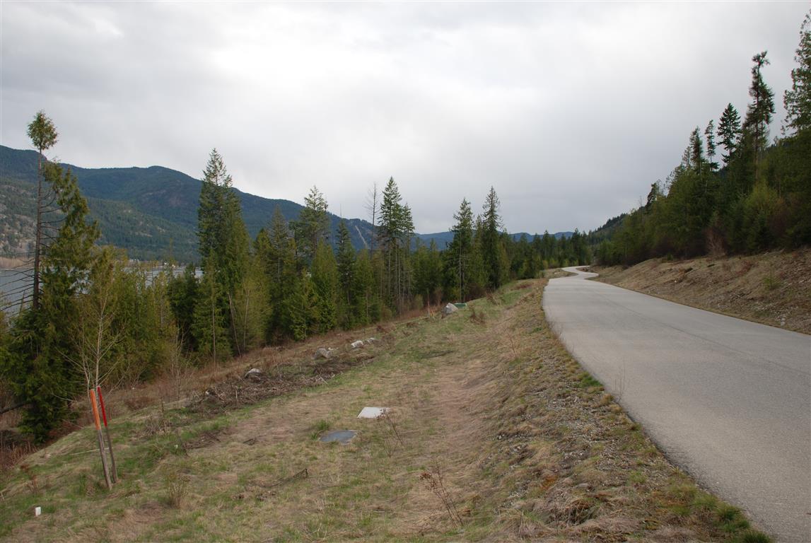
When you visit the property, you will instantly take notice of the quality construction of the roadways which were built about 14 years ago for the adjacent subdivision. The property has a large amount of frontage along Sunflower Road and West Lake Road and power has been brought into the property line. The back section (east side) of the property is quite steep, but as you move down the hill toward the lake the property flattens out with several benches ideal for building your perfect lake view home. With the proper rezoning these lake view benches would serve as perfect location for the areas next subdivision.
Spectacular Christina Lake views and across the street from the beautiful sandy beaches and day facilities of Christina Lake Provincial Park! This is a perfect opportunity to invest in Canada’s warmest tree lined lake.
Recreation is paramount here with some of British Columbia’s finest hiking, biking, kayaking, canoeing, waterskiing, fishing, hunting, quadding, snowmobiling, Nordic and alpine skiing at your doorstep.
West Lake Drive - Christina Lake, BC
Call listing agent for detailed directions to the property.
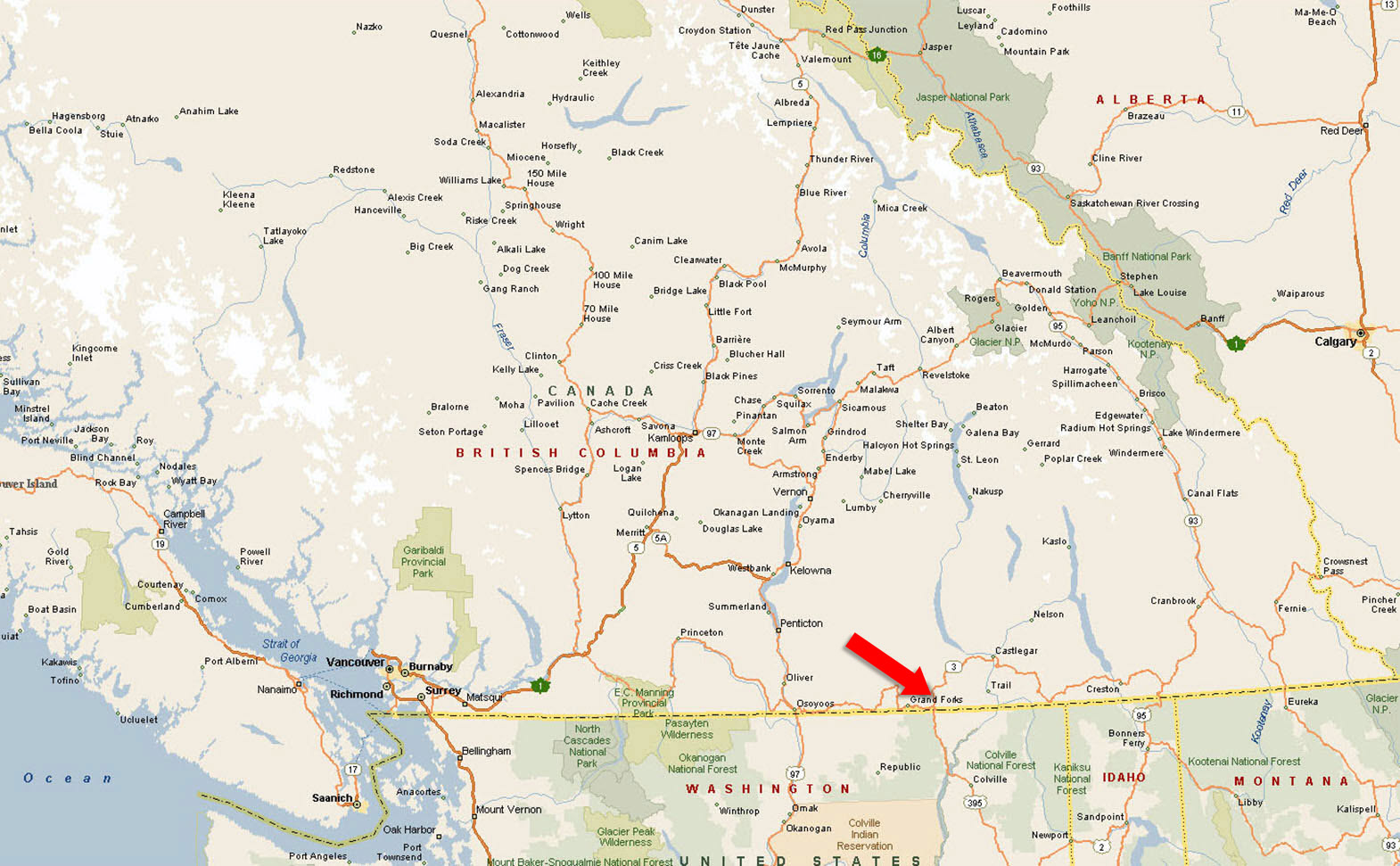
Take Highway 1 east to Highway 3 outside of Hope BC (about 1.5-2 hours), follow Highway 3 to Grand Forks. From there continue another 20 minutes east to Christina Lake. The entire trip is about 7 hours.
Take Highway 33 to Rock Creek. Turn left onto Highway 3 to Grand Forks. From there continue another 20 minutes east to Christina Lake. This trip is about 2.5 hours.
Head west on Highway 3 over the Paulson Pass to Christina Lake. This trip is approximately an hour.
Take Highway 395 north to the Canadian Border (approx. 2.5 hours) continue on 395 until it meets Highway 3. Turn right on Highway 3 and go just about 3 miles to Christina Lake.
Christina Lake is a small, scenic community nestled in southeastern British Columbia, near the US border in the Kootenay Boundary region. The lake itself stretches approximately 18 kilometres and is renowned for having some of the warmest water in Canada, thanks in part to natural thermal springs that feed into it. The year-round population hovers between 1,100 and 1,300 residents, though the number increases noticeably during the summer months as visitors return to seasonal homes or vacation properties.
The Christina Living Arts Centre, envisioned as a hub for arts, culture, and environmental education, continues to be a focal point in the community and remains integral to local events. For instance, during the 2025 Winterfest, the Christina Lake Arts and Artisans Society hosted craft workshops at the Welcome Centre, indicating ongoing community engagement through the arts.
In 2025, Christina Lake saw the completion of a new active transportation bridge over Christina Creek. This bridge enhances safety and provides a more direct route for pedestrians and cyclists, diverting traffic away from the highway and promoting sustainable transportation within the community.
Recognized as “BC’s Favourite Lake,” Christina Lake is renowned for its clean, clear water, scenic beauty, and warmth. While it’s well known as a top family vacation destination, the area offers something for everyone—from those looking to relax to those seeking outdoor adventure and extreme sports.
The climate in Christina Lake features warm, dry summers and relatively mild winters. Average winter temperatures range from -8°C to -2°C, while mid-summer highs often reach well into the 30s. The area receives approximately 42 cm of annual rainfall, enjoys about 120 frost-free days each year, and benefits from over 2,000 hours of sunshine annually. Annual snowfall averages around 44 cm. Christina Lake is also recognized as the warmest tree-lined lake in British Columbia, making it a prime destination for water lovers.
Just west of Christina Lake, the City of Grand Forks sits at the confluence of the Granby and Kettle Rivers. The Granby River forms the city’s eastern boundary, while the Kettle River flows along the south. These two rivers meet in the heart of town and continue south as the Kettle River before eventually joining the Columbia River. Their peaceful flow, sandy beaches, and inviting swimming holes contribute to the area’s charm. In early summer, tubing down the Kettle or Granby is a favourite local tradition, with various entry and exit points depending on how long a float you’re after.
There is something all year round and for all ages! In winter, residents and visitors can enjoy cross-country skiing and snowshoeing right from their backdoors, as well as skating, hockey, and curling at the local recreation complex. Downhill skiing is available nearby at Phoenix Mountain Resort, with more advanced terrain at Red Mountain in Rossland and the deep powder of Whitewater near Nelson.
In warmer months, the lake is ideal for swimming, boating, fishing, kayaking, tubing, waterskiing, and windsurfing. Its sandy beaches are perfect for sunbathing or a casual day by the water. Mountain biking has grown rapidly in popularity, with cyclists taking advantage of the Trans Canada Trail and numerous other scenic routes that pass right through the community. Horseback riding is available at nearby Owl Mountain Ranch, which offers guided trail rides through the surrounding countryside.
Surrounded by mountains, rivers, and forests, Christina Lake is not only a recreation hotspot but also a peaceful place to unwind and connect with nature year-round.
Christina Lake has been home to human activity for over 2,000 years, originally inhabited by the Sinixt people. Their presence is still visible today through preserved pictographs at Texas Point Provincial Park. In the 1800s, the area became part of the Hudson’s Bay Company’s fur trade network, supplying the outpost in Colville, Washington. A local legend credits the lake’s name to Christina, daughter of company factor Angus MacDonald, who is said to have rescued her father’s important papers from the lake’s outlet.
The construction of the Dewdney Trail in 1865 made Christina Lake a key stopping point along one of southern British Columbia’s primary travel routes. Texas Point got its name from a group of Texas Longhorns that roamed the area after straying from a cattle drive. Settlement expanded in the 1890s as gold seekers spilled over from Rossland, and in 1896 the arrival of the Canadian Pacific Railway made the area more accessible to travelers and new residents.
Road access continued to improve through the 20th century. The Santa Rosa Road was built in 1926, followed by the opening of the Blueberry-Paulson Highway in 1962, connecting Christina Lake more directly with Castlegar and Trail. These developments helped shape the community into the year-round destination it is today.
Please see mapping section, all boundaries are approximate.
49° 3'2.01"N and 118°14'18.27"W
Power at the lot line.
$11,740.08 (2025)
NR1
Parcel A of DL 1021S SIMILKAMEEN Division Yale District EXCEPT PLANS 7440, 7441, 7442, KAP81060 AND KAP85268
PID 014-947-811
 +8 maps


Our property descriptions and geographical information are taken from the BC Assessment Authority, Land Titles Office, government maps and other sources. While LandQuest® does not guarantee the information, we believe it to be accurate, but should not be relied upon without verification. This communication is not intended to cause or induce breach of an existing agency agreement.
Cascade
 5℃
5℃
 5℃
5℃