


Gravel pit for sale in Hudson's Hope. This 160-acre pit is estimated to contain 7.5 million cubic meters of gravel. With recent sales to BC Hydro and ongoing regional demand, this is a strategic long-term investment within a high-growth energy corridor. Mine # 1641358 Permit # G-9-293.


 +36 photos


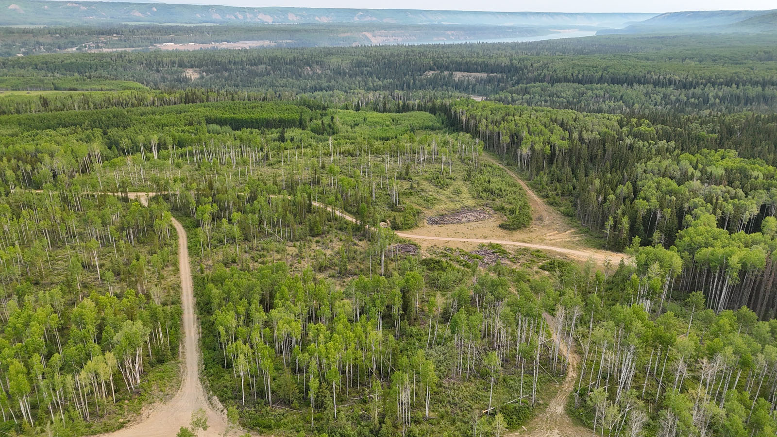


Gravel pit for sale in Hudson's Hope. This 160-acre pit is estimated to contain approximately 7.5 million cubic metres of gravel based on Seller calculations. Over 4,795 tonnes have recently been sold to BC Hydro, with ongoing demand driven by infrastructure and energy development across the region.
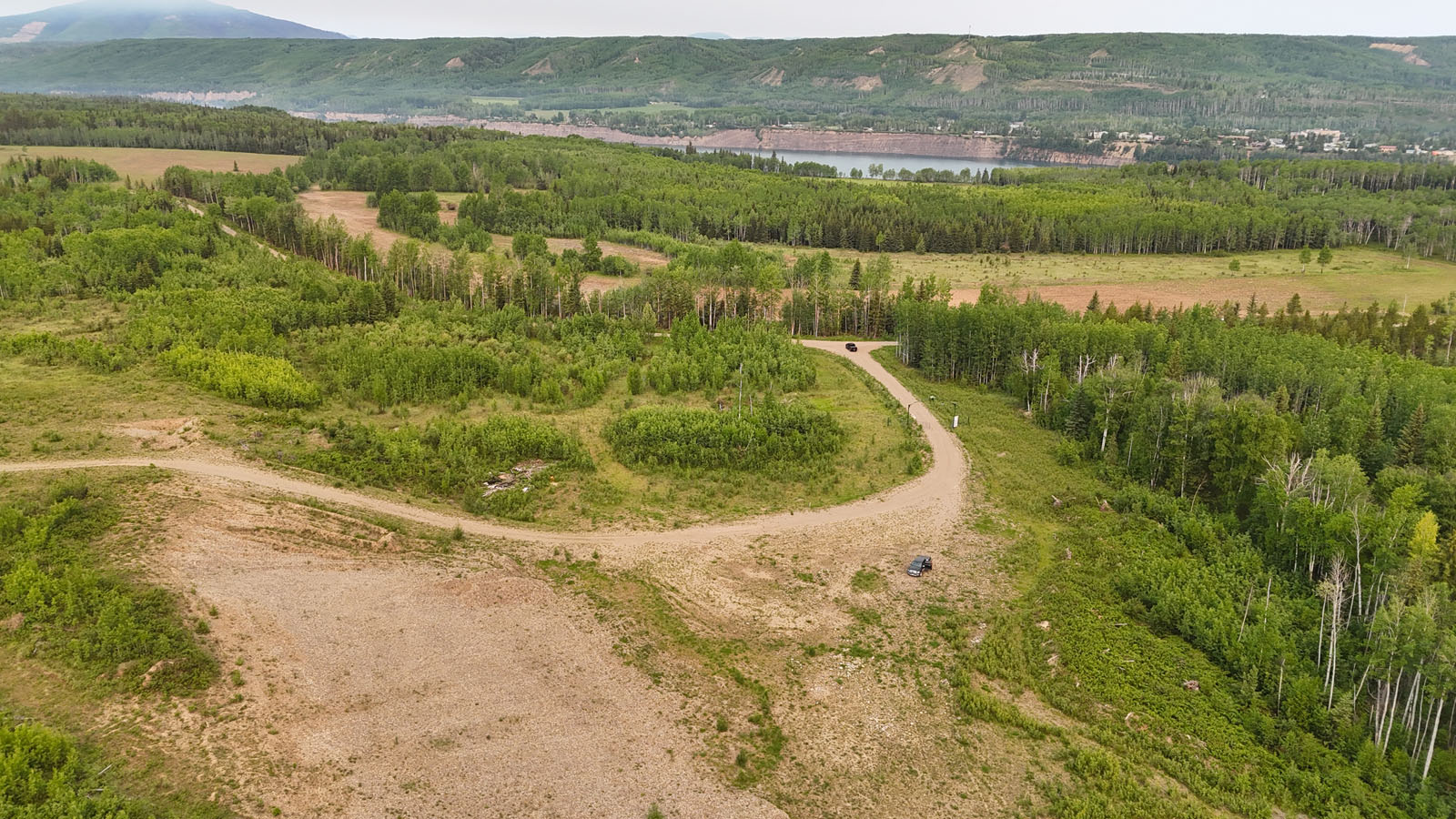
The site is road accessible (90% axle weight) and gated at the entrance. Natural stands of mature poplar add visual appeal and shelter. Situated just a few hundred metres from the new Site C reservoir and near the high-water mark of the Peace River, the property offers added recreational value—camping, hunting, and river access included.
A unique feature of the property is its exclusive access to Maurice Creek Falls, a stunning nearby waterfall only reachable through the subject lands. Maurice Creek itself is a picturesque, seasonal watercourse that flows into the Peace River corridor, enhancing the property's appeal both visually and recreationally.
With renewed momentum in natural gas extraction and federal investment in clean energy infrastructure, Hudson’s Hope is experiencing steady capital inflows. This offering represents a secure, long-term opportunity in an economically active and naturally beautiful region.
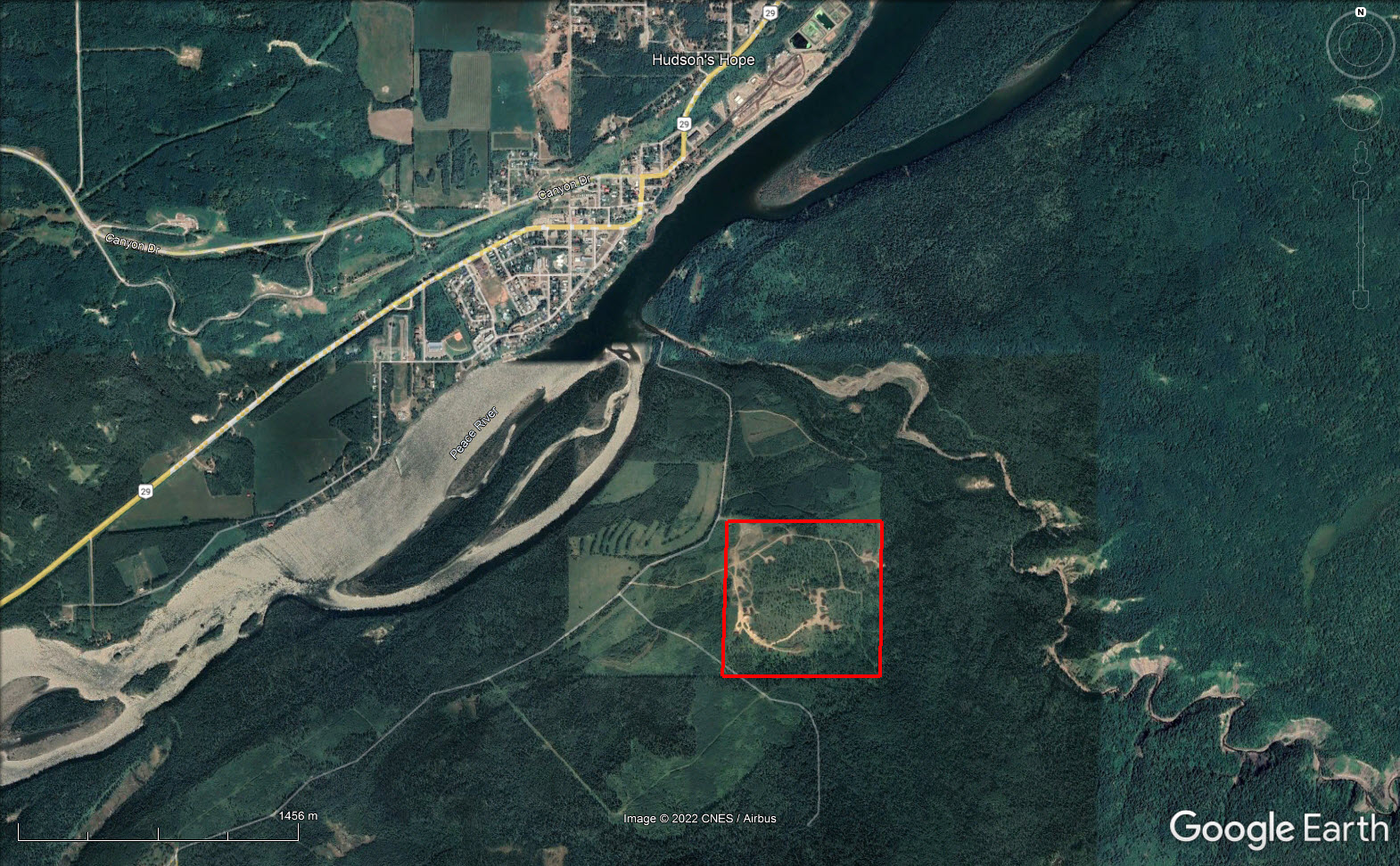
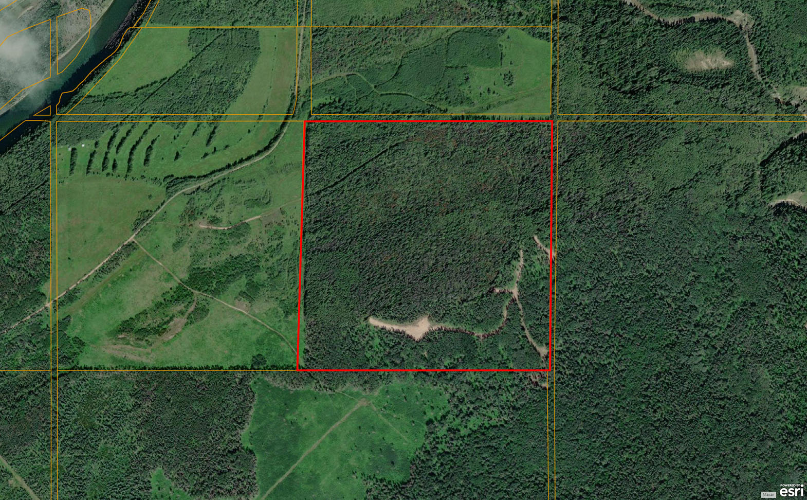
NW ¼ Section 7 Don Phillips Highway - Hudson’s Hope, BC
From Hudson’s Hope head west/southwest on the Don Phillips (29) Highway for approx. 7.5 km. Turn to head east on the gravel road and proceed for approx. 4.5 km at which point the property will be on the south side of the road.
The Peace River region of British Columbia is one of the province’s most dynamic economic corridors outside of the Lower Mainland. The region’s GDP has remained strong, bolstered by over $6.6 billion in annual economic activity, and is forecast to grow steadily through 2025 and beyond.
The region holds vast reserves of natural gas, with northeast BC estimated to contain more than 2,933 trillion cubic feet. The completion of major projects like the Coastal GasLink pipeline and increased liquefied natural gas (LNG) export capacity at the Kitimat terminal are expected to accelerate gravel demand for road, pad, and facility construction.
Hudson’s Hope is also adjacent to the W.A.C. Bennett and Peace Canyon dams, and Site C—the $16 billion hydroelectric megaproject nearing completion—continues to drive infrastructure spending and material demand in the area.
In addition to energy, the Peace Region comprises 40% of BC’s total Agricultural Land Reserve (ALR), supporting over 60,000 head of cattle and more than 22% of the province’s beef production. The fertile soils and relatively low land costs also encourage grain and forage production, making the area a hub for agricultural development.
Property contains mature stands of poplar, native grasses, and brushland typical of the boreal transition zone. Natural regeneration on previously worked areas.
This property affords the modern sportsman with infinite opportunity to test their fortitude and skillsets against an array of big game species. The property lies in game management unit 7-35 where general hunting tags are available for mule deer, whitetail, elk and moose.
Whitetails and mule deer roam in abundance feasting on the various wild grasses and alfalfa. The pockets of timber and topographical depressions provide sufficient cover for bucks to grow to maturity.
Moose frequent the property and surrounding countryside providing excellent sport and table fare for successful hunters. A recent population study, sponsored by Talisman Energy, estimated the moose population in this specific management unit at 1,126 animals.
A large herd of resident elk wander throughout the area and onto the property at all times of year. Butler Ridge provides excellent habitat for calving elk mothers. Larger herds of elk may be seen during periods of heavy snow and cold weather when the herds are pushed to lower elevations and agricultural areas in the pursuit of easily accessible food. The current landowner has harvested numerous trophy bulls from the property.
In addition to hunting, the area immediately surrounding the property is home to excellent fishing opportunities. Some of the fish species available include: northern pike, rainbow trout, bull trout, arctic grayling, Kokanee, walleye and a variety of other species. These fish species may be pursued in the Peace River itself, Williston Lake or amongst the innumerable number of northern lakes and waterways.
If you are into off-roading, quadding, snowmobiling, cross-country skiing, hiking and camping, not only does this property provide you with vast space to pursue such activities, but the immense portions of Crown land, which form the greater landscape, offer infinite opportunity for such pursuits.
In 1793 explorer Simon Fraser and a group of explorers travelled westward along the Peace River via canoe and were the first Europeans to enter the area. These explorers were followed by the Hudson’s Bay Company who established a fur trading post/fort directly across the Peace River canyon from the current town site of Hudson’s Hope.
Although the exact origins of the name Hudson’s Hope are unknown, its first known recording was from 1868. In 1899 the fort was moved to the present-day location on the northern bank of the Peace River.
The area was largely explored by prospectors and survey crews in the early 20th century, as the area was opened to a mineral stake in 1908 and land grants in 1912. In 1942 the construction of the 97 Alaska Highway increased traffic to the region and helped spur the region’s coal mining industry.
Rural and urban development was enhanced by the construction of the W.A.C. Bennett Damn and hydro station in 1962. To help finance and organize the construction of this infrastructure, the Hudson’s Hope Improvement District was incorporated along with the Municipality of Hudson’s Hope. A second dam was constructed in 1980 several kilometres down river from the original dam known as the Peace Canyon Dam.
56° 0'38.14"N and 121°53'44.12"W
Seller estimated 7.5 million cubic meters of gravel. Close proximity to BC Hydro, Site C, and regional energy and road infrastructure.
NA
NA
$500 (2025)
RU-3
THE NORTH EAST 1/4 OF SECTION 7 TOWNSHIP 81 RANGE 25 WEST OF THE 6TH MERIDIAN PEACE RIVER DISTRICT
PID 017-347-696
Mine # 1641358
Permit # G-9-293
Multiple Listing Service®
 +8 maps


Our property descriptions and geographical information are taken from the BC Assessment Authority, Land Titles Office, government maps and other sources. While LandQuest® does not guarantee the information, we believe it to be accurate, but should not be relied upon without verification. This communication is not intended to cause or induce breach of an existing agency agreement.
Moberly Lake
 -18℃
-18℃
 -18℃
-18℃