


LandQuest® Realty Corporation is a unique real estate company specializing in marketing ranches, farms, oceanfront, private islands, marinas, lodges, resorts, lakefront, riverfront, recreational, development, investment, unique, trophy, timbered, fishing and hunting properties throughout British Columbia.

Oceanfront property with custom 3 bedroom, 2 bathroom home, separate studio/guest cabin. Private marina, moorage at your doorstep. Road accessible with services. Ideally situated in the Southern Gulf Islands with easy access to Vancouver Island.
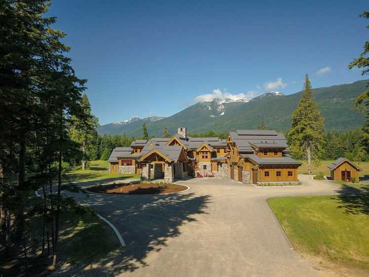
World class ultra luxurious 6,475 ft2, 6-bdrm timber-frame lodge on a 305-acre ranch skirting the banks of the mighty Skeena River is a masterpiece in detail, design & décor. Ranch operators live in a separate caretaker log house on the grounds, so owners can enjoy the unprecedented tranquility.

A true jewel of the Cariboo. This unique ranch property sits perched 200 feet above the mighty Fraser River and offers a unique topographical setup found nowhere else in the province. Set amongst the lush hay fields, pasture and farm infrastructure is a stunning country home offering 4,100 ft2 of living space. This is a once in a lifetime opportunity.
Personal Real Estate Corporation
chase@landquest.com 778-927-6634
Opportunity to purchase 3.5 acres of Commercial zoned property on Highway 20 'downtown' Nimpo Lake. Property offers highway frontage water and power. It is partially treed and in a prime location with scenic lake views.
Foreign Buyer Ban does not apply to this property

8.55 acres along Discovery Passage in the “Salmon Capital of the World”, this serene oceanfront property with an off-grid cabin, 400 ft of water frontage & views of Quadra Island. Roughed-in driveway & an easement for beach entry, all connected to civilization via FSR to HWY 19.
Foreign Buyer Ban does not apply to this property

World class salmon & bottom fishing at your doorstep. This floating lodge is located on Union Island in Kyuquot Sound on the coast of Vancouver Island. 4 guest rooms, a 3-bedroom cabin, dining room, outdoor kitchen area & a fish processing facility catering to guests & other lodges.
Foreign Buyer Ban does not apply to this property

Scenic agriculture land a couple kilometres from Mabel Lake. 446 acres over 2 titles with 1.5 km on the Shuswap River, 100 acres of hay + an additional 20 acres cleared & ready to be seeded. 10,000 ft2 steel hay shed. 120± acres outside the ALR. Zoned for 18 acre lots.

Waterfront, privacy, serenity, hunting and fishing, and the extensive BC wilderness are all at your fingertips. This exclusive offer features multiple dwellings housing up to 32 people, giving plenty of options to retreat from the whirlwind of life.
Foreign Buyer Ban does not apply to this property

Prime 159-acre agricultural farm in Alberni Valley, Vancouver Island, with a history of diverse farming operations. Includes two residences, extensive barns/outbuildings, and abundant water supply. Ready for immediate production, offering a rare opportunity in a sought-after location.
Foreign Buyer Ban does not apply to this property

Fully serviced 135 site RV park on Moyie River with 35 Riverfront sites & 105 inland sites. 101.59 acres (2 titles). 3 bdrm residential house, 5,000 ft2 storage building. No zoning and lots of land for motel, truck stop etc, or there is potential for park expansion (sewer & water for 300+ sites).
Foreign Buyer Ban does not apply to this property

Galena Bay - 7 secluded acres overlooking Arrow Lake. Building site leveled and prepped with concrete garage foundation, dual access driveway, and coniferous trees. Crown land access on north and west. ‘Hot Springs and Recreation Central’.
Personal Real Estate Corporation

Investment opportunity! 52 acres with merchantable timber—2022 timber cruise available, primarily fir and cedar. Zoned R2 & R3 for Country/Rural Residential—subdividable. Quiet/private area yet only 6 km to vibrant Nelson City! Purcell, Selkirk Mountains, and lake views.
Personal Real Estate Corporation

This 153-acre property offers diverse potential as a ranch, multi-family home, campground, or RV park. Year-round creek access, stunning mountain & lake views, & a solar-powered cabin. Its strategic location, favorable zoning & natural beauty make it an ideal opportunity.
Personal Real Estate Corporation

160 acres of pure nature 10 minutes north of 100 Mile House and 4.4 km east off Highway 97. Surrounded by Crown land. Southwest exposure and panoramic views. Suitable for self-sufficient living and would make an excellent off-grid homestead. Seller will vendor finance.
Personal Real Estate Corporation

Picturesque 9.9-acre lot with a season creek, man-made pond and fenced pasture area on beautiful Lasqueti Island. A prime location to set up your own self-sustainable homestead farm on Canada’s warmest island.
Foreign Buyer Ban does not apply to this property
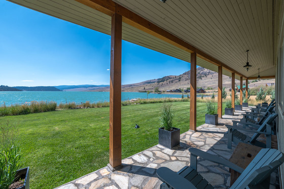
Lakefront living at it’s finest. Professionally designed 2,400 ft2 rancher with courtyard finished with stone floors, exposed timber framing & wood burning fireplace. Swimming pool. High-end Viking appliances. Private guest house. 3 car garage/workshop. 3 hours to Vancouver.
Personal Real Estate Corporation

600-acre ranch that harmoniously blends modern comforts with rugged exploration, featuring a charming 2,200 ft2 log home, a cozy hunting cabin & a spacious shops. Diverse landscapes, abundant wildlife & easy access to recreational activities like fishing & hiking. Near Dorman Lake.
Foreign Buyer Ban does not apply to this property
Personal Real Estate Corporation

140 acres, 4,800 ft oceanfront, and lakefront in the south-central coast. Sheltered moorage, timber, gravelly beach, lake large enough to land a float plane. Possible hydro power generation. Privacy assured, no neighbors here.

Superb 2.46 acres with 252 ft of oceanfront looking southwest across Sidney Channel and James Island to Vancouver Island. Warm, private, flat, fully treed, sloping gently with year-round sunsets. Sidney Island is a private island with common property larger than Stanley Park.
Personal Real Estate Corporation

134 acres combining urban convenience with rural tranquility, offering stunning views & potential building sites bordered by Crown land. Meticulously fenced. Possibility to stratify up to 5 lots, a versatile opportunity for development, personal use, or as a base for exploring.
Foreign Buyer Ban does not apply to this property
Personal Real Estate Corporation

160-acre bare land parcel situated on Jumpingpound Creek. Only a 20-miunte drive from downtown Cochrane. This fenced parcel offers mountain views, 111-acres in hay production, numerous build sites & ample recreational opportunities including great hunting.
Personal Real Estate Corporation

This offering encompasses the main farmyard of the Jumping Pound Ranch. 1.6 miles of frontage on Jumping Pound Creek, fencing, ranching infrastructure & two residences. All of this set against the dramatic backdrop of the Rocky Mountains. Minutes away from Calgary & Cochrane Alberta.
Personal Real Estate Corporation